 The central area of the Newtown Creek is significant for its designation as a public common by William Penn as evidenced in surveys created by Penn’s surveyor, Thomas Holme. The creek served as a vital natural asset providing water, energy and dispersing waste and stormwater for the people that lived on its banks.
1682 – 1796: The Common
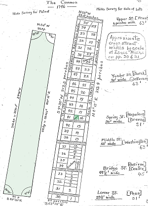
Newtown Townstead was part of a large tract of land that William Penn purchased from the indigenous Lenape people in 1682. The town was surveyed and subdivided by Thomas Holme, Penn’s surveyor, in accordance with William Penn’s circular town plan. The plan included a central Common of over 40 acres along the Newtown Creek, surrounded by privately held lots. The Common, free for us of all, ran from the southern lots sold to the northern lots and was bounded by straight lot lines. It extended from about 90’ sour the of Lower Street (currently called Penn Street) to somewhat north of Upper Street (currently called ‘Frost Lane) The plan allowed each land holder to have a town lot and an adjoining farm area as well as easy access to water and grazing lands. During this period woodlands along the creek were cleared to facilitate farming and animal husbandry. Even before the death of William Penn in 1718, efforts were made to purchase some of the common land and to subdivide the common land among the surrounding land owners who eventually served as the trustees of Newtown Common. (Figure at left: Hick’s Survey of the Common Lots subdivision plan of 1796 From Newtown Commons by Norman W. Swayne)
 1796 – Mid-Twentieth Century: The Common Lots
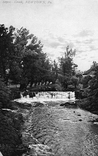
In 1796 the trustees of the Newtown Common held at least one public sale at which the 57 lots were sold to the highest bidder. Several purchasers reneged on the deeds resulting in the ownership of some parcels being contested well into the 19th century. During this period these lands were occupied by predominantly by small town residences and shops. At least one portion of the stream was impounded by a stone dam and diverted into a mill race to turn the wheel of a grist mill at Barclay Street. Maps and documents indicating a foundry, coachworks, agricultural works and stream impoundments leave little doubt that the section of Newtown Creek that passed through the former Common supported a variety of industrial endeavors during this period. The only part of the original Common that was never sold was located between lot 16 and the Newtown Creek at the foot of Greene Street. The remaining public lot, approximately 80’ x 100’ was left open for a public watering place. In 1932, large, natural boulder inscribed with the story of the Common was placed to commemorate the 250th anniversary of the founding of the town. (Figure at right: 1900 postcard image of mill dam on Newtown Creek).
Mid-Twentieth Century to Present: Suburban Development
Since the mid- 20th century, a boom in residential and retail land development have led to increased development in the sparsely-populated farming lands that surrounded the original settlement area. New roads, parking lots, signage, utilities and public facilities along the creek have affected the landscape character and water quality greatly. Land development and management practices have replaced the historically cultivated fields, woodlots and hedgerows with lawns, landscaped roadways and parking areas. The burgeoning white tail deer population and invasive exotic plant species have also served to change the character and ecology of the areas surrounding the creek. Starting in the early 21st century, efforts to restore the riparian functions of the creek have been aided through the following measures:
- Preserving a 6.59 acre tract known as the Rockbridge Property that comprises 1,110 linear feet along the Newtown Creek as open space,
- Creek clean up days sponsored by the NCC


