 The Newtown Creek Coalition (NCC) was established in 2006 by a group of interested citizens living in the vicinity of Newtown Creek along with representatives from the governing bodies of Newtown Borough and Newtown Township. Since its inception, the NCC has held regular meetings that are open to the public, convened public meetings, conducted research and organized clean up events. The Coalition drafted and adopted the following mission statement on April 7, 2007:
To improve, protect and preserve Newtown Creek and to encourage appropriate use of this natural and historic resource by the community.
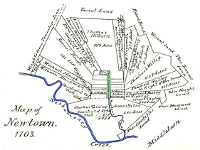
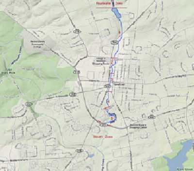
The geographical focus of the NCC is centered on the section of the creek in the vicinity of the historic Common that was established by William Penn when he laid out Penn’s “New Town”. In 2007 and 2008, the NCC convened meetings to solicit input from interested citizens and property owners adjacent to the creek to define the geographical boundaries and characterize appropriate uses for five zones of the creek from the dam, located upstream of Route 532 (Washington Crossing Road) southward to Route 332 (Newtown Bypass). Recommendations for improvements and management specific to each zone were also generated during these public meetings.
 In order to inform the public about the creek and solicit feedback on the zone plan and recommendations for future improvements, the NCC staged public presentations in April 2009 and March 2010. These presentations provided background on the cultural and natural history of the Newtown Creek and Common, the creek zones as they exist today, and an overview of waterfront development precedents in other locations. The presentations were followed by feedback sessions that invited attendees to post their visions about what should be changed or preserved along the creek. The feedback from these meetings was incorporated into plan for the creek drafted by the Heritage Conservancy.
About Newtown Creek
The Newtown Creek is a 9.2-mile tributary to the Neshaminy Creek in the Delaware River drainage. The basin is located in Middletown, Newtown and Wrightstown Townships and the Borough of Newtown in Bucks County Pennsylvania. Newtown Creek is a freestone creek that drains approximately 6.3 square miles and flows in a southerly direction. The surrounding area is characterized by relatively flat topography with some gently rolling hills. A section of the Newtown Creek is impounded to create a flood control/recreation dam. This impoundment is owned by Bucks County and located upstream of Route 532.
The creek is located within USDA hardiness zone 6 which is a conducive to growing many landscape and orchard crops. Today, the adjoining creek banks are managed principally as landscaped lands or woodlands with significant populations of exotic invasive plants.
Additional information on the physical characteristics of the Newtown Creek can be found in the following documents:
- Delaware Riverkeeper Network. River Conservation Plan: Upper and Middle Neshaminy Creek, Bucks County. Delaware Riverkeeper Network, 2003
- EPA. Stream Designation Evaluation Report Water Quality Standards Review: Newtown Creek, Bucks County. April 2004.
- Salas, Dan. Stream Assessment & Recommendations: Newtown Creek, Newtown Township, Bucks County. Delaware Riverkeeper Network, January 2006.